
Introduction
An old township map can do more than show roads, concessions, and lots. When read alongside land grants, deeds, and family records, it becomes a way to see how an ancestor’s life was anchored in the landscape.
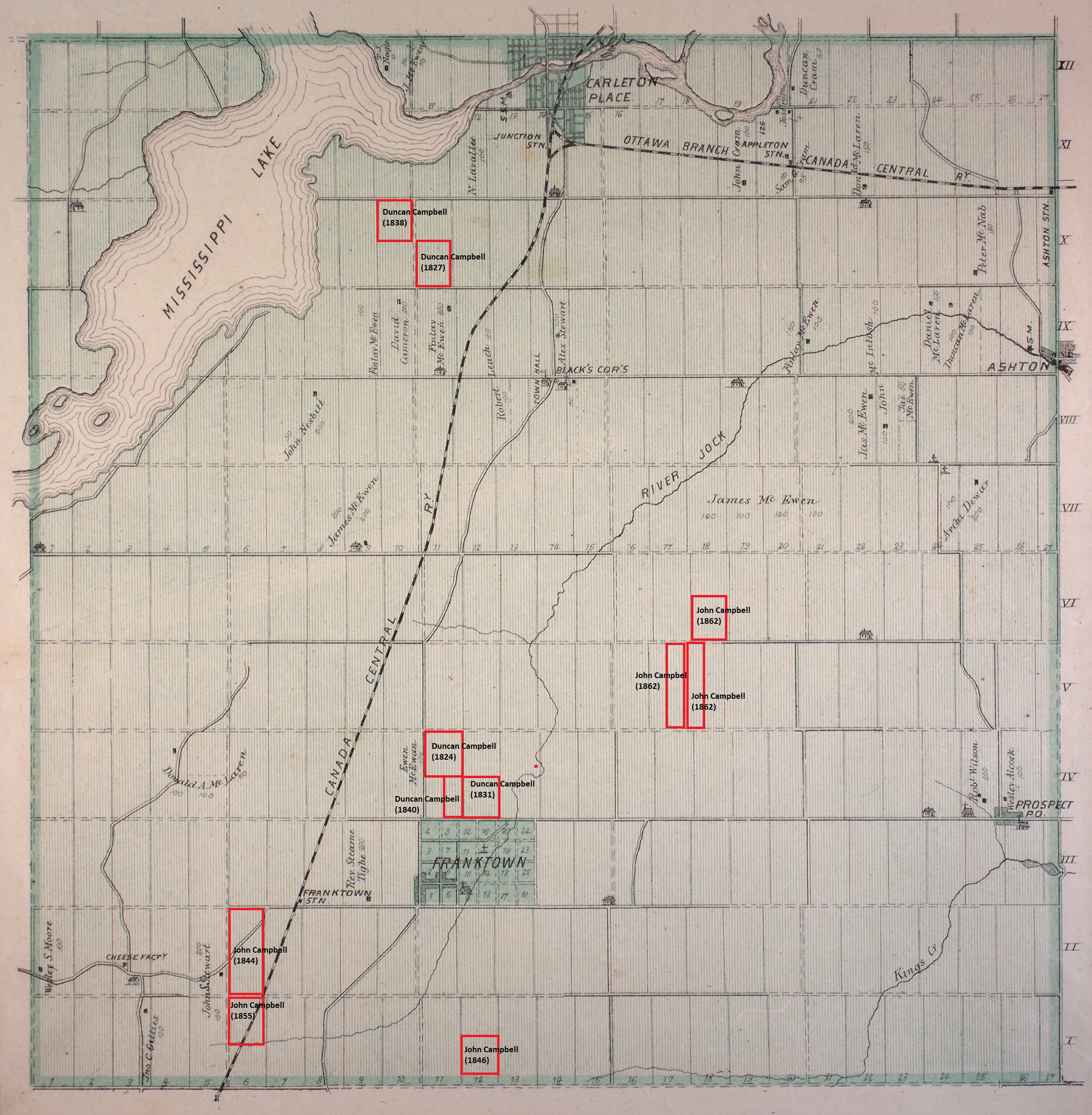
This map study follows the Campbell family in Beckwith Township, Lanark County, Upper Canada and later Canada West. It focuses on Duncan Campbell, an early settler in the township, and his son John Duke Campbell, who continued the family’s landholding presence in the same community. The red outlines on the map mark the parcels currently associated with Duncan, John, and close family members. The map is not simply decorative; it is a visual index to the family’s settlement pattern, inheritance, and movement through the township.
Duncan Campbell’s Beckwith Township Land
Duncan Campbell was an early settler in Lanark County. According to the reconstructed land history, he first settled his Beckwith Township land in 1818 and received a 100-acre land grant in 1824. That grant marked the beginning of his documented landholding in the township.
Duncan’s land position expanded beyond that first grant. Through later purchases and transfers, he appears to have accumulated about 450 acres before his death around 1850. The most important parcels in the current reconstruction are grouped in two areas of Beckwith Township.
The first group lay in Concession 4, Lots 11 and 12, just above Franktown. This block amounted to about 250 acres and was transferred to Duncan’s son Archibald Campbell before Duncan’s death.
The second group lay in Concession 10, Lots 10 and 11. This 200-acre block was associated with Duncan’s son Donald Daniel Campbell, also known as Daniel.
These parcels show Duncan not as a passing settler but as a man who established a multi-parcel family land base in Beckwith Township. The land was both home and economic foundation: fields to clear, cultivate, mortgage, divide, sell, and pass to the next generation.
The Division of Duncan’s Land
Duncan’s land did not remain as a single estate. Before or around the time of his death, it was divided among family members through land transactions and inheritance arrangements. The parcels near Franktown passed to Archibald Campbell, while the Concession 10 land was connected to Donald Daniel Campbell.
That division matters because it shows the transition from a first-generation settler’s accumulation of land to a second-generation family network. The map makes that transition visible. Rather than reading the Campbell story only as names in deeds, we can see the family spread across the concession grid.
Daniel Campbell, Janet Duff, and Their Children
The Campbell land story also included loss and guardianship. Donald Daniel Campbell and his wife, Janet Duff, died soon after Duncan, probably in the early 1850s. Their deaths left young children connected to the land but too young to manage it independently.
Their son Donald Daniel Campbell Jr. went to live with John Duke Campbell, while their daughter Margaret was placed under the care of her mother’s parents. The land therefore became more than property. It was tied to the care of children, the management of inheritance, and the practical question of which relatives would raise or protect the next generation.
John Duke Campbell’s Landholdings
John Duke Campbell, Duncan’s eldest son and a direct ancestor in this line, built his own substantial land base in Beckwith Township. He acquired his first known 100 acres by land grant in 1844. Over the next eighteen years, through grants, purchases, and other transactions, he accumulated at least 700 acres.
John’s landholdings were not static. Some land was sold before his death in 1888. After his death, his wife Elizabeth and his executors sold much of the remaining land, distributing value from the estate to the next generation.
One of the heirs connected to that later division was Peter Campbell, who later farmed near Prince Albert in the North-West Territory. The Beckwith Township land story therefore connects directly to the family’s later western migration. Land acquired in Lanark County helped shape the inheritance and opportunities of children who moved beyond Ontario.
Landholdings at a Glance
| Person | Concession | Lot | Approx. acres | Date / period | Transaction type | Notes |
|---|---|---|---|---|---|---|
| Duncan Campbell | 4 | 11-12 | about 250 | before 1850 | grant / purchase / transfer | Land near Franktown later associated with Archibald Campbell. |
| Duncan Campbell / Donald Daniel Campbell | 10 | 10-11 | about 200 | before 1850 | inheritance / transfer | Land associated with Donald Daniel Campbell and later his children. |
| John Duke Campbell | TODO | TODO | 100 | 1844 | land grant | First known land grant. Verify concession and lot. |
| John Duke Campbell | multiple | multiple | at least 700 total | 1844-1860s | grants and purchases | Exact parcel list should be verified against land records. |
| John Duke Campbell estate | multiple | multiple | TODO | after 1888 | estate sale / executor sale | Sales by Elizabeth Campbell and executors after John’s death. |
What the Map Shows
The annotated map turns a list of transactions into a visible family geography. Duncan Campbell’s landholdings were not isolated points. They formed a pattern across Beckwith Township, with meaningful clusters near Franktown and in the northern concessions. John Duke Campbell’s landholdings extended that pattern.
The map also shows why land records matter in family history. In this period, a family’s land can reveal settlement chronology, relative prosperity, inheritance patterns, guardianship problems, and migration pressure. The Campbell parcels were places where trees were cleared, crops planted, children raised, estates divided, and decisions made about whether to remain in Lanark County or move west.
Current Interpretation
The current reconstruction supports several conclusions.
First, Duncan Campbell established a meaningful land base in Beckwith Township beginning with settlement in 1818 and a formal grant in 1824.
Second, his land was divided among sons, including Archibald Campbell and Donald Daniel Campbell, before or around the time of Duncan’s death.
Third, John Duke Campbell built a separate and larger land base, eventually holding at least 700 acres before selling or passing much of it through estate transactions.
Fourth, the Campbell land story in Beckwith Township connects to the family’s later movement west, including descendants who farmed near Prince Albert in the North-West Territory.
These conclusions should remain tied to the underlying land records. The map is a powerful aid, but the proof rests in the grants, deeds, indentures, estate records, and later family movements.
Research Notes
Parcel placement
The red boxes on the map should be treated as a reconstruction. Each marked parcel should be checked against the original land abstract, patent, deed, or indenture. Where the map labels are based on later ownership or family interpretation, the article should say so.
Duncan Campbell’s acreage
The working total for Duncan Campbell is about 450 acres. This appears to include 250 acres in Concession 4, Lots 11 and 12, and 200 acres in Concession 10, Lots 10 and 11. The exact acreage should be confirmed from the original land records before publication as a final total.
John Duke Campbell’s acreage
The working total for John Duke Campbell is at least 700 acres. The parcel list should be verified before the article states this as a final total. If some parcels were held briefly, mortgaged, or jointly held, that should be noted.
Relationship wording
Check the generational labels before publication. In the original blog-style draft, both John Duke Campbell and Peter Campbell were described as “3x great-grandfather” at different points. That cannot both be correct in the same direct line unless the relationships refer to different people or there is a wording error. Correct the relationship labels before final publication.
Place-name context
This article uses historical place terms such as Upper Canada and Canada West where appropriate. Beckwith Township later became part of Lanark County, Ontario. The article should use the place-name that fits the date being discussed.
Sources
annotated map
Annotated Beckwith Township Campbell Land Map
Citation: Annotated Beckwith Township concession-and-lot map showing Campbell-associated parcels; working archive image, privately held by Davis Simpson, 2026. Original map citation and annotation history to be completed.
Access: Private family-history working file reviewed in 2026.
- Visual placement of currently reconstructed Campbell parcels in Beckwith Township.
- The relationship between the Franktown-area parcels, the northern concession parcels, and John Duke Campbell's later holdings.
land grant
Duncan Campbell 1824 Beckwith Township Land Grant
Citation: Duncan Campbell, Beckwith Township land grant, 1824; exact grant, patent, or land-book citation to be completed from the original record.
Access: Working citation pending verification against the original land record.
- Duncan Campbell's documented landholding in Beckwith Township by 1824.
- The reconstruction that Duncan's Beckwith settlement began before the formal grant.
land record reconstruction
Duncan Campbell Concession 4 Lots 11-12
Citation: Duncan Campbell land associated with Beckwith Township, Concession 4, Lots 11 and 12; exact abstract, deed, or transfer citations to be completed from the original records.
Access: Working citation pending verification against land abstracts and related deeds.
- The working reconstruction that Duncan Campbell held or controlled about 250 acres in Concession 4, Lots 11 and 12.
- The later association of this parcel group with Archibald Campbell.
land record reconstruction
Duncan Campbell Concession 10 Lots 10-11
Citation: Duncan Campbell and Donald Daniel Campbell land associated with Beckwith Township, Concession 10, Lots 10 and 11; exact abstract, deed, or inheritance citations to be completed from the original records.
Access: Working citation pending verification against land abstracts and related deeds.
- The working reconstruction that a 200-acre Concession 10 parcel group was connected to Duncan Campbell's family.
- The later association of this parcel group with Donald Daniel Campbell and his children.
land grant
John Duke Campbell 1844 Beckwith Township Land Grant
Citation: John Duke Campbell, Beckwith Township land grant, 1844; exact grant, patent, concession, and lot citation to be completed from the original record.
Access: Working citation pending verification against the original land record.
- John Duke Campbell's first known 100-acre land grant in Beckwith Township.
- The starting point for the later reconstruction of John Duke Campbell's landholdings.
land purchase records
John Duke Campbell Beckwith Township Land Purchases
Citation: John Duke Campbell, Beckwith Township grants and purchases, 1844-1860s; exact deed, abstract, and registry citations to be completed from the original records.
Access: Working citation pending verification against land abstracts, deeds, and registry records.
- The working reconstruction that John Duke Campbell accumulated at least 700 acres in Beckwith Township.
- The article's caution that the exact parcel list still needs record-by-record verification.
estate land records
John Duke Campbell Estate Land Sales
Citation: John Duke Campbell estate land sales and executor transactions after 1888; exact indenture, deed, and registry citations to be completed from the original records.
Access: Working citation pending verification against estate-related land records.
- The article's statement that land was sold by Elizabeth Campbell and executors after John Duke Campbell's death.
- The connection between the Beckwith Township land base and later family inheritance.